
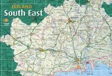
South East Ireland Tourism
Travel guide to Ireland's south east
Travel guide to Ireland's south east
Cahir, Tipperary
Cahir, Tipperary
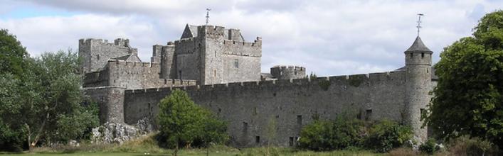
Cahir is a charming and picturesque town on the banks of the River Suir in the south of County Tipperary. The surrounding lands are rich and fertile and the town nestles beneath the protection of the Galtee Mountains. The name in Irish, Chathair, means ‘Stone Fort’. Conor O’Brien, the Lord of Thomond, built a strong and imposing castle on a stony outcrop island in the River Suir in the 12th century. It was around this focal point that the town of Cahir developed. Some of this original castle has been incorporated in the later Anglo Norman Castle, built in the 15/16th century.
The 19th century saw the growth of a major corn milling industry and in Cahir, as elsewhere, this was controlled by the Quaker community. Indeed Cahir was known as the "Quaker Town".
The present appearance of the town dates from the 1840’s when the 2nd Earl of Glengall (Butler) redesigned the town around the Square, often cited as one of Ireland’s most successful examples of the 19th century town planning. For this project, Butler engaged the famous Regency architect, John Nash, who also designed Swiss Cottage.
In recent years Cahir, with its pleasant location and appearance and its wealth of interesting, historical buildings has become a unique visitor attraction. *Cahir has recently twinned with Scarborough in the North East of England.
The Craft Granary in Church Street houses unique quality products and gifts from the South East of Ireland. It also produces it's own range of textile, interior designs such as cushions, throws, wall hanging and framed pieces.
Cahir Park provides a delightful way to pass a few hours.
Equestrian enthusiasts should visit one of the nearby Equestrian Centres, which offers residential and non-residential courses for groups and individuals.
Cyclists can enjoy the stunning local scenery by following the local cycling trails - information available in tourist information office.
The Tipperary Heritage Way is another delightful way of discovering the area. It offers a series of Walks suitable for all levels of walkers.
Situated midway between Cahir and Mitchelstown just off the N8, is Mitchelstown Cave. Stroll in comfort through three massive caverns in which you are surrounded by indescribable drip stone formation.
<< Return to Tipperary page
The 19th century saw the growth of a major corn milling industry and in Cahir, as elsewhere, this was controlled by the Quaker community. Indeed Cahir was known as the "Quaker Town".
The present appearance of the town dates from the 1840’s when the 2nd Earl of Glengall (Butler) redesigned the town around the Square, often cited as one of Ireland’s most successful examples of the 19th century town planning. For this project, Butler engaged the famous Regency architect, John Nash, who also designed Swiss Cottage.
In recent years Cahir, with its pleasant location and appearance and its wealth of interesting, historical buildings has become a unique visitor attraction. *Cahir has recently twinned with Scarborough in the North East of England.
What to see and do in Cahir
Cahir Castle, one of Ireland's largest and best-preserved castles, is the main focal point of the town. The nearby Swiss Cottage is a delightful cottage orne built in the 1800's by Richard Butler.The Craft Granary in Church Street houses unique quality products and gifts from the South East of Ireland. It also produces it's own range of textile, interior designs such as cushions, throws, wall hanging and framed pieces.
Cahir Park provides a delightful way to pass a few hours.
Equestrian enthusiasts should visit one of the nearby Equestrian Centres, which offers residential and non-residential courses for groups and individuals.
Cyclists can enjoy the stunning local scenery by following the local cycling trails - information available in tourist information office.
The Tipperary Heritage Way is another delightful way of discovering the area. It offers a series of Walks suitable for all levels of walkers.
Situated midway between Cahir and Mitchelstown just off the N8, is Mitchelstown Cave. Stroll in comfort through three massive caverns in which you are surrounded by indescribable drip stone formation.
Cahir Map
<< Return to Tipperary page